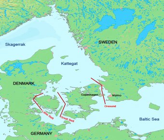
 Are the three sea channels between Denmark and Sweden connecting the Baltic Sea to the North Sea through the Kattegat and Skagerrak. The three chief sea passages are:
- Øresund (Oresund);
- Storebælt (Great Belt); and,
- Lillebælt (Little Belt).
Base Map Source: DEMIS
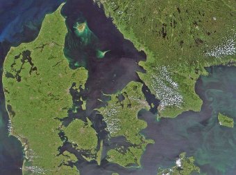
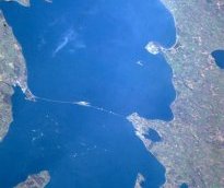
Source: NASA
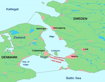
Øresund (Oresund)
Oresund is the eastern-most of the Danish Straits, separating the Danish island of Zealand (Sjaelland in Danish) from the Swedish mainland.
Oresund. The dashed lines at the top and bottom indicated the northern and southern limists of the Oresund. Base map source: DEMIS At its narrowest, between Helsingor'/Elsinor (Demark) and Helsingborg (Sweden), the Oresund is approximately 2.5 miles (4 kilometres). A ferry connects the two sides, but the construction of a tunnel is under consideration.
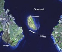
Oresund Link
In 1991, the governments of Denmark and Sweden agreed to build a bridge to connect the two countries across the Oresund Strait.
The 16-kilometre-long Oresund Link between Malmo, Sweden (right), and Copenhagen, Denmark (left), was completed and opened to traffic in 2000.
The Oresund Link has three main segments.
Oresund coast south of Kullaberg. @ C. Michael Hogan
 On the Denmark side, the link begins with a 3510-metre (2.2-mile) underwater tunnel.
- The tunnel emerges from the water onto a roadway on a 4055-metre (2.5-mile) artificial island, Peberholm, which appears as a bright white shape to the south of the natural island in the scene below.
- The cable-supported Oresund Bridge stretches 7845 metres (4.9 miles) across the eastern part of the Strait toward Sweden, producing a thin white line across the image.
This image of the Oresund Link was acquired April 10, 2004. The large image is centered near 55.6 degrees North latitude, 12.7 degrees East longitude, and it covers an area of 50.8 by 25.9 kilometers. Deep water appears dark blue, shallow water appears bright blue, vegetation appears green, and developed or paved areas appear white. Several white specks in the waters of the Strait are boats or ships. . Source: NASA/GSFC/METI/ERSDAC/JAROS, and U.S./Japan ASTER Science Team
Storebælt (Great Belt)
Storebælt (Great Belt) is the middle and widest strait of the three main Danish Straits. It passes between between the main islands of Zealand (Sjælland) and Funen (Fyn). Being the widest, it is the main channel for vessels passing between the Baltic Sea and the North Sea.
The Great Belt is sometimes viewed in two parts: a "northern zone" between Zealand and Funen (The Great Belt proper); and, a "southern zone" between the islands of Langeland and Lolland (a strait called Langelandsbaelt).
 Base map source: DEMIS
South of the Great Belt is the Bay of Keil which lies off the north coast of Germany. The Baltic Sea to the east is reached through the Fehmarn Belt.
|
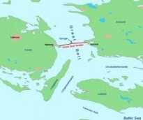
The Great Belt is crossed by the Great Belt Bridge (Great Belt Fixed Link) which connects a point just south of Korsor on the island of Zealand to Nyborg on the island of Funen As shown in the images right and below, the mid point of the bridge is the island of Sprogø. |
|
|
Source: Dr Kjaergaard/Wikimedia Commons |
A suspension bridge (4.2 miles, 6.8 km "East Bridge") carries a road from Korsor to Sprogø, while two connected tunnels convey the rail link. The suspension bridge has the world's third longest main span: 5328 feet or 1624 m, under which the main shipping lanes pass.
A "box girder" bridge (4.2 miles, 6.6 km "West Bridge") connects Sprogø to south of Nyborg. This bridge has two separate spans, one for rail and one for road traffic. The Link openned in 1998.
Lillebælt (Little Belt)
Lillebælt (Little Belt) is the western most and narrowest of the straits. As such it is not generally used by larger vessels.
The strait is at its narrowest (just 800 metres) between the island of Funen (Fyn) and the mainland of Denmark (Jutland), where it crossed by two bridges:
- the "Old Little Belt Bridge" (3865 feet, or 1.2 km) originally serving rail, road and pedestrians, but now carrying just a rail link; and,
- the new "Little Belt Bridge" (1.1 mile, or 1.7 km), a suspension road bridge.
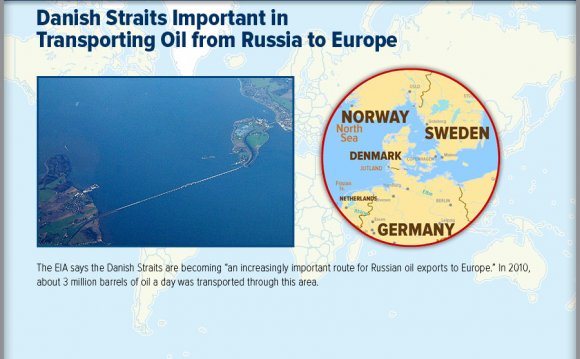
Energy
About three million barrels per day (bbl/d) flowed through this waterway in 2010, with most of this product moving westward. Russia has increasingly been shifting its crude oil exports to its Baltic ports, especially the relatively new port of Primorsk, which accounted for half of the exports through the Straits. An estimated 0.3 million bbl/d of crude oil, primarily from Norway, flowed eastward to Scandinavian markets.
About one-third of the westward exports through the Straits are for refined products, coming from Baltic Sea ports such as Tallinn (Muuga), Venstpils, and St. Petersburg.
Citation
Saundry, P., Administration, E., & Administration, N. (2013). Danish Straits. Retrieved from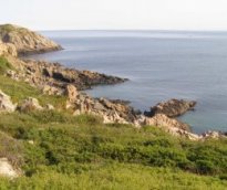
RELATED VIDEO


RELATED FACTS
-
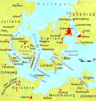 The Danish straits are the three channels connecting the Baltic Sea to the North Sea through the Kattegat and Skagerrak. They transect Denmark, and are not to be confused with the Denmark Strait between Greenland and Iceland. The three main passages are:
By closer...
Share this Post
latest post
-
 North Sea Restaurant DC June 29, 2023
 -
 North Sea oil drilling May 30, 2023
 -
 North Sea Radio Orchestra April 30, 2023
 -
 Overfishing in the North Sea March 31, 2023
 -
 North Seas March 1, 2023
 -
 North Sea oil and gas jobs January 30, 2023
 -
 Offshore catering jobs North Sea December 31, 2022
 -
 Map of North Sea oil Platform December 1, 2022
 -
 North Sea Cycle Route November 1, 2022