We provide forecasting services for any location around the world. We specialise in setting up customised domains to offer detailed information for wind farms and high resolution forecasts of ocean and coastal conditions.
Our marine forecast solutions can be configured to whatever scale required – for example resolving the wave energy gradients behind an island, throughout an oil field or along a shipping channel and into a harbour entrance. The aim is to provide you with the forecast information you need in the actual location that you need it.
The main products are:
- Wave heights of the sea and swell
- Wave directions of the sea and swell
- Peak (dominant) period of the waves
- Wind speed and direction
- Tidal elevations
- Currents induced by tide and wind
- Harbour long waves
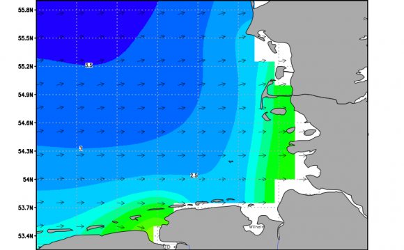
Check out the North Sea demo of the MetOcean Forecast System, the North Sea Forecast maps and/or the general weather site "Weathermap":
We can also provide directional spectra, spectral widths, shape parameters and modal estimates, and wind at various elevations. Forecast data are produced on 6-12 hourly cycles and made available as graphs, maps or text at hourly intervals out to 7 days ahead. Winds are from GFS or nested WRF domains, waves from nested WW3 / SWAN, and current from nested POM domains.
All of the forecast products are distributed through a web-based interface with the following features:
- Easily accessible to clients from their desktops.
- Forecasts can be accessed on the water using web-enabled palm pilots or mobile phones
- Easy to use, high resolution maps
- Clear visual aids (colour coding for wave heights, and vectors for wind and swell direction) to clearly show events
- General information is updated 3-hourly using the latest available information
- with hourly updates available for site specific locations
- XML schema on file outputs allows integration to other end user applications
- Site-specific forecasts can be implemented within 24 hours
Let us know your marine weather forecasting requirements, and we will provide you with technical details of a reliable solution.
This web-based tool allows a weather forecast to be extracted along a pre-defined ship route based on waypoints. The duty forecaster or operations manager simply inputs the latest position and speed of the vessel, and then our server selects the best available forecast information along the route for the next 7 days. These data can be served as text files or as graphs and daily charts of winds and waves with the vessel and route overlaid. Data available include:
- Significant and maximum wave height
- Peak period and wave direction
- Visibility
RELATED VIDEO

Share this Post
latest post
-
 North Sea Restaurant DC June 29, 2023
 -
 North Sea oil drilling May 30, 2023
 -
 North Sea Radio Orchestra April 30, 2023
 -
 Overfishing in the North Sea March 31, 2023
 -
 North Seas March 1, 2023
 -
 North Sea oil and gas jobs January 30, 2023
 -
 Offshore catering jobs North Sea December 31, 2022
 -
 Map of North Sea oil Platform December 1, 2022
 -
 North Sea Cycle Route November 1, 2022